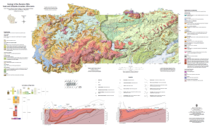
The 2025 publication Geology of the Baraboo Hills, Sauk and Colombia Counties, Wisconsin (link) showcases the range in geologic time visible in the Baraboo Hills, from rocks that are over 1.7 billion years old, to sand and gravel deposited during the last ice age only 24,000 years ago, both in a map as well as a detailed scientific report.
Covering popular outdoor recreation areas that include several State Natural Areas and Devil’s Lake State Park, collaborating geologists have gathered new data from the field and the lab to answer ongoing questions about the geological history of this much-loved landscape.
This work expands our understanding of continental-scale geologic history, and will be used by educators, geoscience researchers, and outdoor enthusiasts ready to explore the Hills.
The map is available for free to download at its intended size (poster) for printing, and is georeferenced for use with mobile apps.
Keep scrolling for more information about the available files!
Visualizing rock deformation
How did the Baraboo Range form? Check out the video below!
Want a printed copy?
Our digital maps are designed to be printed to scale, roughly the size of a poster.
- To print a map to scale: this will require a large-format printer, also called a plotter.
- Download the .pdf file from the Publications Catalog (see “Map files” below)
- Print on a large-format printer, or work with your local print shop
- To print on a standard printer: Due to re-scaling, the text will be very small.
Want to explore this map with a mobile device?
This statewide map has been georeferenced to allow for added functionality, including viewing within mobile apps.
To load a map to a mobile app: this requires a GPS-enabled mobile phone and app such as Avenza Maps (link).
-
- Download a copy of the .pdf to the mobile device
- Within the mobile app, import the downloaded file to view
Need geospatial data?
Geospatial datasets are used for creating maps. Download from the Publications Catalog (see “Map Files” below).
Map Files


More information
Learn more about the project here (link)
For more details, contact one of the following WGNHS geologists:
- Eric Stewart, eric.stewart@wisc.edu
- Esther Stewart, esther.stewart@wisc.edu
- Billy Fitzpatrick, william.fitzpatrick@wisc.edu
