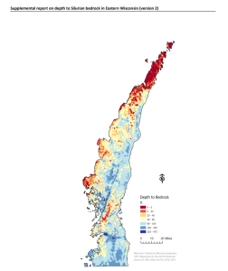
Silurian-aged bedrock in eastern Wisconsin is shallow, fractured, and contains groundwater that is susceptible to surface water contamination. Revisions to Wisconsin state rules ATCP50 and NR151 to regulate manure spreading over this Silurian-aged bedrock create the need for a depth-to-bedrock map of eastern WI. The goal of the original project was to develop a method for producing a data-driven DTB raster relevant to groundwater quality rules in the region that can be updated as new data are made available.
In 2025, the Wisconsin Geological and Natural History Survey created a depth-to-bedrock raster surface with 5-foot and 20-foot contours over the 4,750 square-mile study area (DOI). In 2026, the authors used newly available input data and an updated DEM of ground surface with the same methods as in DS004v1, to calculate a new version (DS004v2) of the depth-to-bedrock raster for Silurian dolomite in Eastern Wisconsin. This update was funded by the Natural Resources Conservation Service (USDA).